Pinned Items
Recent Activities
-
Cr Karen Morrisey OAM, Chair - Murchison GeoRegion Project Working Group has just released an excellent presentation about the Murchison GeoRegion delivered at a recent conference in Perth. Recommended viewing.Post is under moderationStream item published successfully. Item will now be visible on your stream.
-
Post is under moderationStream item published successfully. Item will now be visible on your stream.
-
AUSTRALIAN GEOTOURISM DISCOVERY PORTAL
Geotourism is an increasingly popular trend within the Australian tourism industry, as more individuals seek out distinctive and authentic travel experiences that allow them to explore a destination's natural and cultural heritage. These experiences not only offer travellers a unique adventure but also effectively communicate the significance of geoscience to the wider Australian community.
To support and enhance the delivery and interpretation of high-quality natural and cultural heritage content, with a focus on geology and landscape, the National Geotourism Strategy (NGS) was established in 2021. As a result, there is a growing need for a technology platform that can provide an up-to-date inventory of Australian geotrails, geosites, mining areas, and cultural sites.
A digital platform prototype has been developed, known as the Australian Geotourism Discovery Portal. This platform serves as an information hub for various user personas, enabling them to discover and explore a wide range of attractions and destinations across Australia. The platform boasts a user-friendly interface and easy navigation. Users can explore the platform by state or GeoRegion, and each geosite, geotrail, mining site, or cultural site, is accompanied by detailed descriptions, photos, and available amenities. This allows travellers to gain a sense of what to expect before their visit. The platform is accessible through desktop and mobile browsers, ensuring that travellers can plan their trips conveniently while on the go. Furthermore, the platform can potentially integrate with other travel tools, such as booking and transportation services, to offer a seamless travel experience.
The prototype of the Australian Geotourism Discovery Portal is set to be launched in Q3 2023. During this phase, the platform will be made available to potential partner organisations and NGS stakeholders. Moving forward, the next steps involve aggregating data from diverse sources, including geological surveys, partner organisations, and public spatial repositories. This process poses a significant challenge and necessitates cooperation and support from multiple stakeholders. Subsequently, in Q4 2023, an evaluation will be conducted to assess the prototype's suitability and effectiveness. A public release of the platform is scheduled for late 2023 or early 2024.
If you are interested in contributing to the advancement of the Australian Geotourism Discovery Portal and assisting with these next steps, please reach out to the Chair of Working Group 1 - Digital Technologies, Mark Williams E: Mark.Williams@utas.edu.au. A presentation by Mark to the recent AESC 2023 conference in Perth, Western Australia about this platform can also be accessed at https://lnkd.in/ga4deQar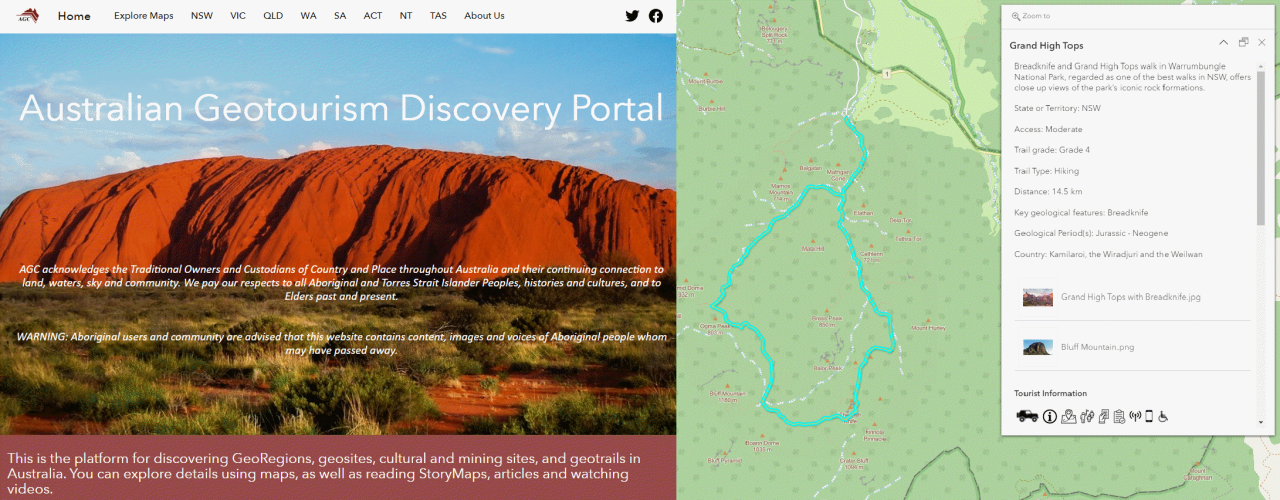 Post is under moderationStream item published successfully. Item will now be visible on your stream.
 -
As a member,LEISURE SOLUTIONS® recommends joining Tourism Central Australia to build networks in the Red Centre https://www.discovercentralaustralia.com/Post is under moderationStream item published successfully. Item will now be visible on your stream.
-
LARAPINTA TRAIL FIELD GUIDE IS NOW AVAILABLE
The Northern Territory Division of the Geological Society of Australia is delighted to announce their first publication: 'Behind the landscape of the Central Ranges' by GSA Member Dr Anett Weisheit.
The ~230 km long Larapinta Trail in Tjoritja / West MacDonnell National Park crosses the West MacDonnell and Chewings Ranges west of Alice Springs in the Northern Territory in the traditional lands of the Aboriginal Arrernte people. This region is rich in biodiversity, Aboriginal culture and local history, all intimately connected to the stunning landscape of steep gorges with secluded waterholes, long ridges and parallel valleys, bluffs and mountain massifs. Behind that landscape lie geological and geomorphological features that are exceptionally well exposed and accessible during day- and multi day-walks. Rocks along the Larapinta Trail feature a variety of types, minerals and structures, and vary in age between the Quaternary (a few thousand years) and the Palaeoproterozoic (thousand million years).
This field guide explains the geology and features of the landscape to the interested walker. The almost 60 stops along the trail and in Alice Springs also include additional information on culture, history and ecology, helping walkers to connect with this extraordinary part of the Central Ranges in Australia’s arid zone.
Pre-orders are now open! http://bit.ly/gsant-pubs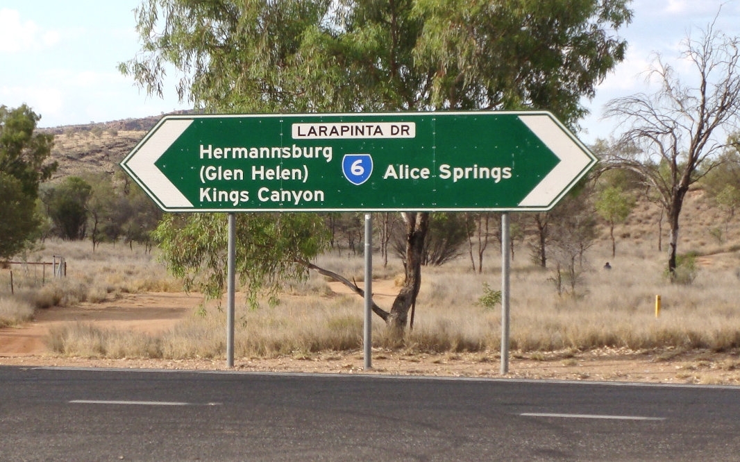 Post is under moderationStream item published successfully. Item will now be visible on your stream.
 -
John Sheridan reacted to this post about 10 months ago
 GEOREGIONS ON THE MOVE!
In accordance with the National Geotourism Strategy, the Australian Geoscience Council has recommended (and the State/Territory Geological Surveys has recently confirmed) that groups wishing to establish a potential geopark, using the mechanism of ‘GeoRegions’, should explore various alternative options for geotourism development. The concept of GeoRegions underpinning an initial exploratory step is also now accepted by the Australian government geoscience agencies to establish the merits of potential geopark development, to gain a high level of community awareness, and to gain support from government agencies.
An approved GeoRegion is defined as an area that is recognised as an area of special natural and cultural heritage highlighting outstanding geoheritage features within which proposed geotrail and potential geopark projects can be developed in support of geotourism. https://youtu.be/FqnsbEcp62E
As a first step, a full audit of natural and cultural heritage attributes in the proposed GeoRegion as well as early discussions with state/territory based Geological Surveys, Planning and Environment agencies, and any other state/territory government agencies responsible for land and resource management is strongly recommended.
The GeoRegion mechanism therefore provides a framework to undertake comprehensive consultation with a full range of interested or impacted community groups (including Aboriginal communities) and to resolve any identified land tenure conflict issues that may arise.
The commencement of the GeoRegion assessment process is defined by a proponent (which might include for example Local Government (LGA), or a Regional Development Authority (RDA) having completed preferably an approved tourism Destination Management Plan, or alternatively a community or special interest group interested in geotourism development.
In developing global geopark proposals, UNESCO appreciates that each Nation State can implement its own procedures for assessment. In the case of Australia, the concept of establishing a GeoRegion as a strategy is an important first step for geopark proponents to use, and is of local relevance only and would fall away if a GeoRegion project supported by the relevant State/Territory Government is morphed into a Geopark nomination. UNESCO is comfortable with what is being developed in Australia in this respect as it is clearly understood that this concept is only a ‘domestic construct.’
Early consultation with relevant state/territory agencies that have land and resource management responsibilities and/or planning and environment responsibilities within the proposed GeoRegion, and this should include the relevant Geological Survey as well as those LGAs with jurisdictional responsibilities.
To date, Australia has three approved GeoRegions – Murchison (WA) and Ku-ring-gai and Glen Innes (NSW).
Post is under moderationStream item published successfully. Item will now be visible on your stream. -
Post is under moderationStream item published successfully. Item will now be visible on your stream.
-
Well 'nature-based' tourism is put simply, geotourism! Take Canberra's Tidbinbilla's Nature Reserve as an exemplar - a 'unique place to experience nature and culture', one of many 'geosites' in our national capital, refer presentation by Douglas Finlayson https://lnkd.in/gN5FtUnu
Other geosites include the National Rock Garden (located in the National Arboretum) and not forgetting the expansive Geological TimeWalk https://lnkd.in/gfEhtCwd managed by Geoscience Australia.
VisitCanberra is leading the development of a long-term tourism strategy for the Canberra region in the Australian Capital Territory that links to the recently-released national strategy for Australia’s visitor economy (THRIVE 2030) that will be used to inform the development of the ACT’s 2030 Tourism Strategy. This includes Action 7.5 to 'grow and develop high-quality products and experiences around unique Australian locations and themes, including approaches which integrate sustainable nature tourism with economic opportunities for Traditional Owners, and capitalising on emerging tourism trends such as geotourism.’Post is under moderationStream item published successfully. Item will now be visible on your stream. -
AUSTRALIA’S BEAUTIFUL LANDSCAPES
FLINDERS RANGES WORLD HERITAGE AREA NOMINATION
Over the past decade, geotourism enthusiasts associated with the National Geotourism Strategy (NGS) have been actively involved in, and have championed, Australia’s National Landscapes (ANL) Programme because of the opportunity to promote geotourism concepts. The Programme was the first time the tourism sector, nature conservation managers and tourism advocacy organisations had worked closely together to present Australia’s top nature tourism (dare we say geotourism) experiences. The Programme facilitated coordinated tourism planning and management and provided a focus for international marketing, but has subsequently been discontinued.
Australia’s 16 nominated National Landscapes Programme included the Flinders Ranges in South Australia. Most of these landscapes comprised a variety of high quality, scenic experiences (related to their natural heritage values) and offered the opportunity to be promoted for their scenic values (i.e., their ‘beauty’). Inspired by the screening of a recent international documentary series titled 'The World’s Beautiful Landscapes’, it is timely to take a close look at what Australia offers in this regard.
The Flinders Ranges comprises a variety of outstanding landscapes including Wilpena Pound. They contain a number of areas set aside for protection and management of the region’s natural, cultural (particulalry Aboriginal) and historic values, on public, private, and leasehold land. Pastoralism has also had a strong historic influence in the region. The region’s rich values and breathtaking landscapes make the Flinders Ranges an iconic geotourism destination with unparalleled visitor experiences.
Beauty aside, from a geological perspective in meeting the key WHA nomination natural criteria (viii) , the Flinders Ranges is significantly an outstanding example representing major stages of earth's history, including the record of life; that is the evolution of complex, multicellular animal life. This contributes to defining the nomination’s ‘Outstanding Universal Value’. In short, the Flinders Ranges is the only place known on Earth where two great experiments in the evolution of complex multicellular animal life i.e, the Ediacaran radiation event and the Cambrian explosion of life, outcrop in a near-continuous geological succession spanning 350 million years.
In a 'Public Talk' hosted by Geoscience Australia in Canberra on Wednesday 22nd March 2023, the concept of geotourism was explained by reviewing the natural and cultural heritage characteristics of the beautiful Flinders Ranges landscapes in the context of its WHA nomination. The presentation also explains the implementation of the NGS which is providing a major opportunity for regional development, focusing on both natural and cultural heritage, both mining and Aboriginal. The presenttion can be viewed at https://www.youtube.com/watch?v=xSZYTvBq05oPost is under moderationStream item published successfully. Item will now be visible on your stream. -
Post is under moderationStream item published successfully. Item will now be visible on your stream.
There are no activities here yet